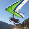
Please allow me to introduce myself. My name is Len Clements. I am a Phoenix area hang glider pilot with about 13 years experience in our sport.
My work has recently taken me to southern parts of Arizona.
It is the nature of hang gliding that we tend to go to the same launch sites, over and over, because it is convenient to do so. Why “reinvent the wheel” by pioneering a new site if we already have places to launch?
For me, it is very difficult to argue with this logic.
However, it is also nice to dream about the possibilities of someplace new…
Just for fun, I’ve been scouting out a new, potential hang glider launch site. One that might someday join the short list among Arizona’s finest. This site is located in a remote part of southeastern Arizona, far off the beaten track. Nestled high in a dense, old growth forest this place features stunning views, awesome camping and fishing.
Did I mention that it has incredible potential as a hang gliding site!?
You may have heard of Mt. Graham, in southeastern Arizona, near Safford. Mt. Graham is actually the tallest peak in the Pinaleno Mountains, a range that stretches for more than 20 miles with a crest at 8,000-10,700 feet.
For our purposes, I’ll refer to the area as “Mt. Graham” because that is the way most people know this place.
Mt. Graham is often referred to as a “Sky Island,” a high alpine environment surrounded by desert. As such, some animals have evolved here apart from similar species elsewhere. For example, the Mt. Graham Red Squirrel is a distinct species, slightly different from millions of other common Red Squirrels in the world. This rodent may make it next to impossible to open a launch here, because of court ordered protection for the Mt. Graham Red Squirrel. But let’s not give up quite yet….
Mt Graham has actually been flown, years ago, by at least two, hang glider pilots that I’m aware of: Eric Smith of Tucson and Rik Fritz of Flagstaff. I believe both launched from the road, on the south face, something that appears impossible now due to the overgrowth of trees and other vegetation. Please do not even consider trying this today; I’ve noticed a strong law enforcement presence on Mt. Graham. Any attempt to launch there without the required approval would almost certainly doom any long term chance we might have for a legitimate launch.
The actual peak, which I believe has potential as a launch site, is called Heliograph Peak: 10,028 MSL. That’s 2,200 feet higher than Mingus!
A paved highway leads up to a locked gate. Beyond that, an easy 2WD dirt road leads right up to the tower complex at the summit of Heliograph Peak. I’ve identified at least three, potential launch sites up there facing northeast, east and southeast. Some trees would need to be cut to clear a launch, however, most if not all of the trees are already dead from a fire long ago. I also think a ramp would need to be built for added ground clearance and stable footing.
For a look at Heliograph Peak and more details about it’s potential, please take a look at my photo album on this website. Double click on the photos, to open them full screen and read the full caption information at the bottom.
Please let me know if anyone thinks this is worth pursuing. It would be a lot of work, probably next to impossible to gain Forest Service approval but maybe it’s worth a try…..
A New Launch?
Moderators:ioan, John Wolfe, aaroncromer, jlowery
Mt Graham
Len, Count me in. Rick and I drove that Mt. this past spring looking for a launch site. Rick went back last Sat. with a map he obtained from Bob Buxton (he may of also flown there), but also said it was too wooded.
Let us know what we can do to help-Jeff
Let us know what we can do to help-Jeff
-
Len Clements
- Posts:10
- Joined:Wed Sep 13, 2006 11:26 am
Here's a rough outline, of a process to follow, that I have roughed out in my head, in order to progress toward a Heliograph Peak launch:
1. Is there sufficent interest? How many people would actually fly there?
2. Is it safe and viable? Let's get together and hike up there, have you guys take a look. What do you think?
3. How many are willing to help "get-er-done?" Who will help with the politics (USFS) of getting approval? The ramp construction work? The money to build the ramp?
Let's see how many post a response to this thread, good or bad, yea or ney, let's hear what people think.....
Len. Welcome to Southern Az. I think you'll find that the pilots are much better looking here than the ones up north.
Not to stand in your way to develop a new site, but if we were to cut a deal with the USFS to launch there, I expect that they'd want site insurance as they do for all of the other places that we launch from on USFS land. SAHGA currently insures 5 sites to the tune of ~$850/year. A few of which are seldom flown. Sorry- but the responsibilities of SAHGA Treasurer weigh heavy upon me at times.
Mt. Graham is a long drive from Tucson and has a very long turnaround as well. Flying here gets suggested every year, but we seldom can field enough Tucson pilots to even go out on a decent looking Saturday to one of our more local sites. It's a rare flying day that we have more than a handful of pilots. Frankly- Mt. Graham hasn't garnered much interest. Jason Otto planned a camping trip there a few years ago, and that was the last time anyone ventured up there with wings. I forget if they flew or not. Dustin also headed out that way a couple years ago, and ended up flying off some hill near Safford instead.
If you're looking for some new, exciting and challenging place to fly in Southern AZ- I'd recommend Mt. Lemmon as a start. All the work has been done. We pay the insurance, the launch is cut clear, paved to the top, it's really BIG, has XC potential and an LZ within a reasonable glide. And- it's seldom flown. We do have to contact the folks who manage the observatory to let them know we'll be coming- so contact Eric Smith.
-
Len Clements
- Posts:10
- Joined:Wed Sep 13, 2006 11:26 am
Morey:
Thanks for the input. This is pretty much what I thought, however, I wanted to at least ask.
My work takes me to Safford and Willcox, quite a bit, as well as Tucson from time-to-time.
I do want to fly your developed sites, I've been skunked twice at Miller but I haven't given up hope. I'd also like to give the Whetstones a shot, Mt. Lemmon, etc.
I'll be down your way in early October: the 3rd (Tues) thru the 8th (Sun).
Maybe I can hook up and fly with you guys.
Thanks!
i went up there with bill lemon and chad koester about 4 or 5 years ago and bill flew his pg off the east side, but only from a 200 foot ledge near the bottom. we found the old launch where nightwine pounded in, or was it schroeder? in any case the undergrowth and trees had closed in making a launch impossible in any area on the road up. plus the road is only at 9 grand and the whole point of graham is that it's 10700! so why deal with that? i think the chances of getting permission to construct a ramp and operate out of there are like winning the lottery...a couple times. i'll help build it but i can't offer much in the way of negotiations. there are better people for that job. i think any launch direction is fine, considering it will be flown about once a year...i think we could cherry pick the day to accomodate. however it is a high mountain and on most days even in the mornings with sun on the east face i believe you will have a west wind. the best vertical drop would be toward safford though, exactly 8000 feet from the peak. you will make safford on a glide absolutely without a doubt no problem. judging glide from that altitude is tough but i would figure on making 12 miles in the worst case scenario. that would be like 7 or 8 to 1 and that would get you to town. that is in case you didn't find a bump in a vertical mile and a half of gliding. i say go for the cheese, get a launch on graham, the height is the point of that place right? and i will take this opportunity to plug my vario and gps one more time...600 bucks, i mean come on!! vario, pod, gps, VERY accurate polar for a topless glider...i'm GIVING it away!
-
Len Clements
- Posts:10
- Joined:Wed Sep 13, 2006 11:26 am
It is a site that would be rarely used. This is actually a plus, I would think, in dealing with the Forest Service. They might be more receptive to the idea if we voluntarily agreed to limit the number of hang gliders in a given period of time.
If it costs $850/ year to insure five sites now, that works out to $170/site/year. If we were to manage Heliograph Peak launch, as a separate entity and charge, say $10 for each day a pilot launches then 17 pilot launches could cover the insurance cost for a whole year!
I havn't completely given up on this just yet....
Len,
I first flew the Peneleanos in 1978. I `ve only flown there half a dozen times over 20 years. I have launched a couple dozen local pilots from there. Back in the day when we flew more and talked less.I did land in the meadow on top once! We called it sky camping, that`s another story.
I would love to fly there and applaud your efforts. If I can be of any assistance please feel free to call, 520-790-3507. I will help raise the money for the insurance, a better use for club funds I can not conceive.
The site does lay down wind of Tuscon making for a long retreive once you get away.
What type of property is the proposed launch site on? National forest? perserve, etc. If you like I will check this out with the regional forester?
Just to see how receptive they are or are not. Is the Scope a concern?
Enviromentalist? etc.
Eric
-
Len Clements
- Posts:10
- Joined:Wed Sep 13, 2006 11:26 am
Eric:
The proposed launch is on the east face of Heliograph Peak. This is in the Safford Ranger District of the Coronado National Forest.
The site is on ordinary USFS land, however, it is restricted by a "Special Closure" to protect the Mt. Graham Red Squirrel. As such, motor vehicle access is restricted, on the Heliograph Peak Road (FS Road- 352) to, "Persons with a permit."
What does it take to get a permit? I've seen many vehicles going up and down this road, during my scouting hikes. They are there to service the radio communications equipment located at the tower complex on top of Heliograph Peak.
I chose this specific site because:
It is the highest point on the mountain, that I could find, at 10,028 feet with a steep and fairly clear area for launching that also has vehicle access. It also has room to set up at least 3 or 4 gliders without blocking the tower maintenance vehicles.
On the downside:
The east face has two rather small, scalloped bowls. Unlike Mingus, with a long, straight east face, I'm concerned about how consistent these smaller bowls might be at channeling in a consistent airflow for launching.
Any launch here would require cutting some trees, perhaps only half a dozen with a launch ramp. Most of the trees which need to be cut, if not all of them, are already dead from a fire. I'm concerned about the USFS reaction to the idea of cutting trees and building a ramp in the "Special Closure" area? I think our impact would be minimal, however, I hope that they don't expect a $250,000 Environmental Impact Study.
If you have not already done so, please view the photos, in my album, on this site for a look at the area. Open the photos, full screen, to read the captions at the bottom. This provides much additional information.
Eric, if you can approach your contact, with the USFS, to get a preliminary feel for their receptiveness to all of this, that's probably a good place to start. My concern is that how we approach this and who we approach could make a big difference in the outcome. If your contact is an even tempered and reasonable sort then I would say go for it.
Beyond that, if we have even a half dozen pilots who are interested in this, I propose that we set a date to hike up Heliograph Peak. How about the weekend of October 7th-8th? It's an easy hike: about two miles up a 2WD dirt road with a 1,000 foot elevation gain. I would like for you, Eric, and anyone else who might be interested in flying the Pinalenos to have a look. I want to hear what you guys think about this site, after seeing it firsthand, before we go too much further.
I know we have at least three AHGA pilots who are very interested, perhaps even more.
As for the expense, if it is only the insurance and the cost of building a ramp (not an EIS) then I think we can work that out. I do not intend for the SAHGA to foot the entire bill for this! Perhaps the AHGA would be willing to help. If not the entire AHGA then we as individuals may step up, putting money where our mouths are! Also, I kind of like the "fee-for-launching" concept. I'd gladly pay $10 per launch for such an awesome site!
October Hike
Sounds like a good project to me.
It shouldn't be hard to get $200 from both clubs combined.
It might be cool to get a multi-club project going.
It would also promote cross club memberships maybe?
Build the ramp like the wood ones built last spring.
Did the sign say you "could or could NOT" ride bikes up there?
I'm up for a good mountain bike climb if its followed with a down hill cruise back.
It would also be a good excuse to get some exercise. The extent of my exercise this summer has been lifting a 60 pound glider on a truck and running 20 feet with it 5 times in the last 8 weeks. LOL
You could call it the "Flying Squirrel project" ah maybe not.
Mark
Mt. Graham
I lifted this from a great website:
http://www.summitpost.org/mountain/rock ... raham.html
"The higher elevations of the Pinaleno Mountains, including Mount Graham itself, are located within the Red Squirrel Refuge. Therefore, the summit of Mount Graham is officially closed to hikers, although some people still hike up to it. Originally, it was thought that the Red Squirrel lived only at the higher elevations of the Pinalenos. However, more recent studies have shown that the Red Squirrel population is actually more numerous at the lower elevations, calling into question the effectiveness of the refuge closure area. "
If your a hiker you may know of this site already, if not, Arizona has 109 listings and " Mount Graham makes an impressive appearance on the Ultra-Prominent Peaks List, coming in at No. 20, and surpasses such notables as Mount San Antonio, Humphreys Peak, Borah Peak, and Pikes Peak. The biggest of the desert southwest’s “sky islands”, the Pinaleno Mountains contain more life zones than any other mountain in North America."
All the more reason to build a Ramp!
Jeff
-
Len Clements
- Posts:10
- Joined:Wed Sep 13, 2006 11:26 am
Len,
We have a good relationship with the forest service. I will inquire about Heligraph peak and access. I am not comfortable showing up there with a group with out getting permission. I can see everthing I need to see on an aerial for now, and not disturb any one.
I do prefer to fly the south west side of the mountain as that faces the prevailing winds. The south west side will have more over all exposure to the sun on an annual basis. No matter, let`s take a look.
This place could end up being a greater vertical than the Lemon.
-
Len Clements
- Posts:10
- Joined:Wed Sep 13, 2006 11:26 am
Another spot on Mt Graham...
If your going to spend some time up there, you should map a hike out to "Grants Point". There is an old road that leads right to it, but it's been closed for years for the red squirels benifit. Small trees are now growing up in the middle of it. It meets the paved road on the south side, just past Hospital Flat.
But it's a beautiful SW rock knoll looking out over huge view. Like Mingus or Miller. Arjan told me he flew his PG from there once.
I have pictures from a recent camping trip if you want me PM them...
Ken
But it's a beautiful SW rock knoll looking out over huge view. Like Mingus or Miller. Arjan told me he flew his PG from there once.
I have pictures from a recent camping trip if you want me PM them...
Ken