REVSION DATE: 12/21/2024
Overview
Mustang Mountain is one of the more popular southern Arizona flying sites, known especially for its late afternoon/evening glass offs. The highest point of the range, elevation 6,469 feet, has no official name and is usually called Mustang Mountains Highpoint. It is located 10 miles east of Sonoita - 70 miles southeast of Tucson.
This part of Arizona is high elevation (about 4,000 feet) grass valleys surrounded by large “sky island” mountain ranges such as the Santa Rita, Huachuca and Whetstone Ranges. The Mustangs sometimes get overshadowed by these larger ranges and visitation here is comparatively low. Most of the range is surrounded by ranch properties, but there are public access points, mostly via lands incorporated into the Las Cienegas National Conservation Area (BLM). Visitors may be surprised to learn that this area is part of Arizona wine country.
It is one of the most beautiful flying locations, featuring the adjacent and quite photogenic “Biscuit” pinnacle. It is flown year-round in W to SW winds, most often during glassoff, but can offer great midday XC conditions as well. Conditions can be somewhat unpredictable, and can easily become blown out.

Site Requirements
- Strongly recommend USHPA and SAHGA Membership
- H2, P2
- CAUTION: Read all the general requirements and warnings here.
Skill Requirements
- This site can be flown, from launch to the large LZ, without any special skills.
- RS is required for ridge-soaring and glass-off sessions.
General Rules
- Mustang sits on BLM land. Pilots are reminded to be a good stewards of the site to ensure future access. Close all road gates behind you.
Know Before You Go
- Using the provided images, familiarize yourself with the details and potential hazards of the site.
-
This flying site is directly below NOTAM R-2303B (see map below). Typically, this airspace is active Monday - Friday, 7AM- 5PM above 8000’ MSL (as of this writing). This gives a ceiling that allows sufficient clearance for typical launch and ridge soaring PG/HG operations.
- This flying site site is just north of NOTAM R-2303A (see map below). Typically, this airspace is active Monday - Friday, 7AM- 5PM from Surface level to 15000'. Crossing the ridge south of the Venturi Area prior to 5PM puts you unneccasirly close to breaking airspace.
- Bring your own windsock
- In strong westerly winds, getting blown over the back is a very real possibility. Winds aloft are often stronger than what is forecasted. Launch is very close to the peak of the mountain. In strong conditions launching may be possible, but maintaining forward progress once above launch may not.
- Be aware of the forecasted changes of wind direction and conditions.
- Actual winds are typically 3-5 mph stronger than the forecast indicates.
- Winds aloft can be considerably different than those on launch or in the LZ, particularly in high pressure weather. Single-digit wind speed in LZ is usually indicative of double-digit wind speed on launch.
- If winds are northwest aloft, the "biscuit" (the nearby butte - you'll know it when you see it) produces turbulence.
- Don't land in fields north and west of LZ due to hostile landowners.
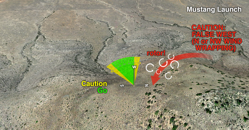
- The large rock outcropping directly North of launch often produces a false West wind on launch when the wind direction is sufficiently North. THIS IS ROTOR, DO NOT LAUNCH. More than one pilot has fallen prey to this phenomenon.
- The same rock outcropping can produce mechanical turbulence above it in strong wind. Exercise caution when flying low over it.
- The valley between launch and the peak to the south is prone to venturi effect in strong wind. Use caution when crossing this valley.
Site Description
Parking
- 31.693570, -110.503280 (Google Maps link)
- Dirt parking lot on the west side of the barbed wire fence at the end of the 2WD dirt access road.
- Directions: From AZ-82, south on Upper Elgin Road, west through gate access at 31.6906118,-110.5228752 (look for windmill on right side of road), take right fork on 2WD dirt road to LZ.
Facilities
- There are no facilities at the LZ or on launch. The nearest restrooms are in Sonoita.
Launch
- 31.701973,-110.491733. (Google Maps link)
- WSW-facing, grassy (with hidden rocks) slope accessed by a ~45 minute, 1.1-mile, 960’ vertical hike from LZ at about 5,900 MSL.
- The first half mile of the hike is mostly flat, leaving about 0.6 mile to climb 960 vertical feet. (GPS track log link)
- Soarable in about 8 mph winds.
- PG Winds: 0-12mph, 8mph ideal, max gust 5 mph over 5 seconds
- HG Winds: 5-15mph, 10mph ideal, max gust 5 mph over 5 seconds
- Rarely flyable if winds aloft are forecast over 12mph at 6k, 16mph at 9k. Don't launch in winds over 12mph!
Wind Direction: “Go” 230°-270°, “Caution” 220°-295° “No-Go” (Rotor produced by rock outcropping) 295°-315° - About 50m down the slope, the terrain drops off abruptly, becoming a rocky, cactus-studded, steep slope. Downwind launches here are very dangerous.
- Be cautious of false W wind caused by N/NW wind wrapping around the rocky outcropping N of launch.
Designated Landing Zone
- 31.693599, -110.502656. (Google Maps link)
- Very large field adjacent to the parking area at about 5,000 MSL
- Beware of the barbed wire fence between the parking area and LZ
Flying

- After launching in strong conditions, fly straight away from the mountain to ensure you can penetrate and escape the lift band.
- Keep wind direction in mind when flying near the biscuit, as it produces mechanical turbulence in stronger winds.
- With enough altitude above launch, it is possible to cross the valley south of launch and make it to the southern part of the mountain range. This is typically done in westerly winds. Most pilots bypass the ridge on the south side of the valley as it tends not to produce usable lift.
- It's an easy glide to the LZ from launch. Give yourself a margin for error when landing, as overshooting could put you into the barbed wire fence between the LZ and parking area.
- When flying in the evening, ensure you fly away from the mountain as the sun sets. Evening catabatic flow generally produces sinking air near the mountain.