I hiked from the LZ up the front side of Box Canyon to the PG launch yesterday to see how easy it might be, since it's my impression that one of the main reasons that we don't go up there as often as we could is that it's such a logistical pain. I also wanted to compare wind conditions with what was predicted by XCskies.
Well the hike turned out to be as brutal as I've heard it can be: steep with virtually no trail, many slippery rocks hidden by tall grass. It took me 1 hour and 20 minutes to the top, ascending about 2000 feet.
I feel like this site would be more usable, at least for me and others willing to hike, if we had a real trail. With some trail maintenance, the hike could be a pretty straightforward 1 hour to the top with a fully loaded PG kit.
Anyone know what we are allowed to do in terms of trail maintenance on the front side of Box?
The XCskies forecast turned out to be very accurate.
Thanks,
--Aaron
Box Canyon hike
Moderators:ioan, John Wolfe, aaroncromer, jlowery
Re: Box Canyon hike
Hi, Aaron
West of the National Forest boundary is Arizona State Trust land. We don't maintain a group permit for that land any more, we instead rely on individual recreational use permits. Under the terms of those permits, you aren't allowed to do anything to alter the land.
Having said that, the land is also leased to ranchers and the UofA for grazing and I can't imagine any objection to anything that looks like a cow path.
East of the National Forest boundary, where the hard part of the hike lies, is the Coronado NF, and we could ask for and perhaps get permission to do real trail improvements. Eric Smith is the guy to talk to about how to submit a formal proposal.
But again, if there's no heavy construction involved, no concrete poured, and we aren't removing anything from the land, I can't imagine any objections to brush trimming and minor shovel work. Eric could inquire about that as well if you would like more assurance than just a guess from me.
These are my personal opinions, of course. I don't speak for SAHGA, the USFS or the Arizona State Land Department.
Also, see if any of the HG guys are headed out when you're thinking of flying there, and if so catch a ride up the back. We don't walk anywhere.
Another idea - one that has been used in the past - is to drive to between the two sharp bends in the road on the backside with a high clearance 2 wheel vehicle, hike an extra mile (on a road), then hike the nice backside trail. After flying, a second vehicle (a regular passenger car) drives to where the road gets tough and lets the driver of the first vehicle hike a 1/2 to maybe 3/4 mile to his vehicle. It is easier than it sounds. The trip back home on RT 83 is nicer than FR485.
Lew
Lew
Aaron,
We've had a pretty decent trail to the top in the past, but with few people flying Box recently, it has obviously grown over. Even when it was a well used trail, it was hard to find if you didn't know exactly where to look. I think it was 2 years ago, we had a number of us go out there with clippers and implements of destruction, and re-cleared the trail, and I put up streamers about every 100ft all the way there and up. I expect they're long gone and as soon as it cools down a few degrees- it will be time to re-invigorate Box for the winter.
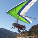
Box, from a PG point of view, is a decent site, and is arguably the most reliable soaring in SoAz. The launches and LZ are not as forgiving as Mustang, but the normal wind direction and velocity is much more favorable.
We used to always hoof it up to the top, and then Gunter moved to town. He got to the 1st knoll, took one look and realized it would be much easier to thermal to the top than hike, and almost ever since, hikes to the top have been fairly rare.
It's a brutal hike- but it gets easier each time and you'll learn to love it.
We've had a pretty decent trail to the top in the past, but with few people flying Box recently, it has obviously grown over. Even when it was a well used trail, it was hard to find if you didn't know exactly where to look. I think it was 2 years ago, we had a number of us go out there with clippers and implements of destruction, and re-cleared the trail, and I put up streamers about every 100ft all the way there and up. I expect they're long gone and as soon as it cools down a few degrees- it will be time to re-invigorate Box for the winter.
Box, from a PG point of view, is a decent site, and is arguably the most reliable soaring in SoAz. The launches and LZ are not as forgiving as Mustang, but the normal wind direction and velocity is much more favorable.
We used to always hoof it up to the top, and then Gunter moved to town. He got to the 1st knoll, took one look and realized it would be much easier to thermal to the top than hike, and almost ever since, hikes to the top have been fairly rare.
It's a brutal hike- but it gets easier each time and you'll learn to love it.